


16 January 2024
20 April 2020
An overview of satellite observations contributing to sustained climate applications, reflecting the large spectrum of benefits of satellite data for different applications.
A better understanding of climate change and its impact is necessary for governments and decision makers to define and implement appropriate mitigation and adaptation policies, including investment policies for large infrastructure with long lifecycles.
This requires the development of science-based climate services, in synergy with weather services, within the Global Framework for Climate Services (GFSC) recently established by the World Meteorological Organisation. Climate services are based on the combination of long series of well calibrated observations, numerical models capable of delivering climate prediction at seasonal to decadal scales and projections at longer scales (in response to emission scenarios), and socio-economic data.
The related requirements for observations of Essential Climate Variables (ECV) are established and maintained by the Global Climate Observing System (GCOS) programme.
Exploiting the Value of Operational Meteorological Satellite Programmes
Monitoring ClimateWith more than 30 years of consistent data, meteorological satellites are an invaluable asset for climate monitoring and understanding of our changing climate, and their role will grow increasingly important with the next generations of systems.
However, exploiting this potential requires dedicated international efforts for recalibrating and reprocessing data, extracting climate records, and making them available to downstream applications and scientists.
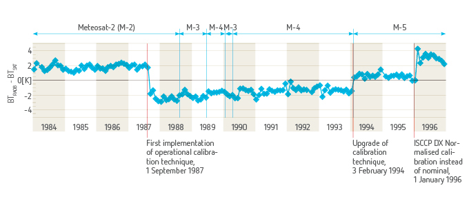
Each instrument or satellite has its own characteristic such as sensitivity to Earth signals, evolution of performance over time, or orbit stability. In addition, calibration and processing algorithms are continuously improved over the course of a mission. Therefore, a simple concatenation of data in time would show jumps when a satellite is changed or artificial trends for some satellites in a series, and would not be useful for climate analysis. The figure at left shows the differences (in Kelvin) between clear sky infrared Brightness Temperatures from successive Meteosat satellites and those calculated from night-time radiosonde data available each month. Re-calibration and cross-calibration are an essential prerequisite to arrive at homogenous time series of measurements across successive satellites that are useable for climate studies.
After re-calibration and cross-calibration it is possible and necessary to reprocess data into basic physical measurements (radiances, reflectances, etc.) to produce long series known as Fundamental Climate Data Records.
These FCDRs form the raw material for climate analyses, from which geophysical parameters, in particular Essential Climate Variables, can be reprocessed to form Thematic Climate Data Records (TCDRs), which can then be validated against independent climate data.
These climate records can then be used directly, or assimilated into the best available numerical prediction models used in 'reanalysis' mode to produce consistent climate records of a broader range of variables.
The Role of EUMETSAT in Climate Monitoring
EUMETSAT climate monitoring activities involve the Central Facilities in Darmstadt and the network of Satellite Application Facilities (SAFs) – with a leading role for the SAF on Climate Monitoring.
They rely on capacities developed to perform all tasks required to deliver validated Fundamental and Thematic Climate Data Records from its data archives, from recalibration and cross-calibration to reprocessing, quality control and ultimately delivery to the climate community. These include data archives, software libraries and dedicated reprocessing environments available in Darmstadt and at Satellite Applications Facilities, in particular at the SAF on Climate Monitoring.
With regard to calibration, EUMETSAT is a core contributor to the Global Space-based Inter-Calibration System (GSICS) project, which provides an international platform to create calibration products to improve the consistency of the data received from various satellites. GSICS develops common methodologies and implements operational procedures to ensure quality and comparability of satellite measurements taken at different times and locations, by different instruments, operated by various satellite agencies.

Jason-2 sea level trends, July 2008-November 2012. The methodologies developed in GSICS are applied to the reprocessing of historical data, for instance within a EUMETSAT-led project of the Sustained Coordinated Processing of Environmental Satellite Data for Climate Monitoring (SCOPE-CM) initiative, which provides consistent physical measurements from all geostationary satellites flown by EUMETSAT, JMA and NOAA.
EUMETSAT is also contributing, together with NOAA, NASA and CNES, to the operations of the climate-dedicated Jason-2 altimeter satellite, which is expanding the unique sea level climate records initiated in 1992 by the Topex-Poseidon precursor. EUMETSAT is planning to operate the follow-on High Precision Ocean Altimetry satellites on behalf of the European Commission, with the Copernicus initiative.
Click here to learn more about our climate-related products.
Delivering to European Climate Projects
EUMETSAT contributes to selected climate projects involving international partners, in particular those co-funded by the European Commission FP7, like ERA-CLIM.
The ERA-CLIM project, started in 2011, involves a consortium coordinated by ECMWF. Its objective is to develop observational datasets (atmospheric, oceanic and terrestrial) and a high-resolution global reanalysis capability that are suitable to perform a global reanalysis over the past century in the years 2014-2016, under a follow-up project called ERA-CLIM2.
EUMETSAT provides ERA-CLIM with Fundamental and Thematic Data Records for all its instruments and some third party missions. In the future, the project will also expand to support the Copernicus Climate Service under definition by the European Commission.


